

Publish QGIS maps to the web in one click
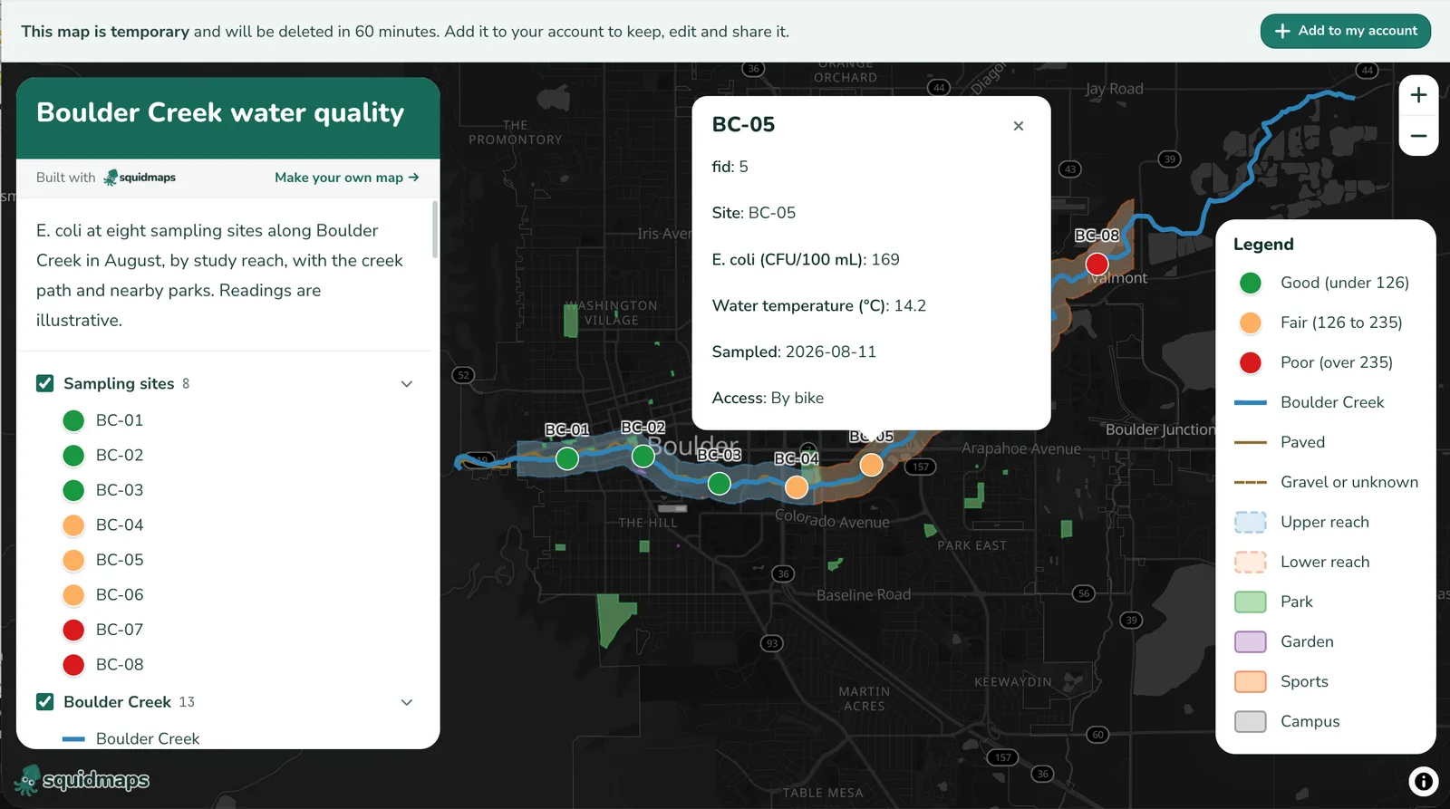
qgis2squidmaps turns your QGIS layers into a squidmaps map, styled as they are in QGIS, with popups, a legend and layers people can turn on and off. You get a link to share. There's nothing to host, and no HTML.
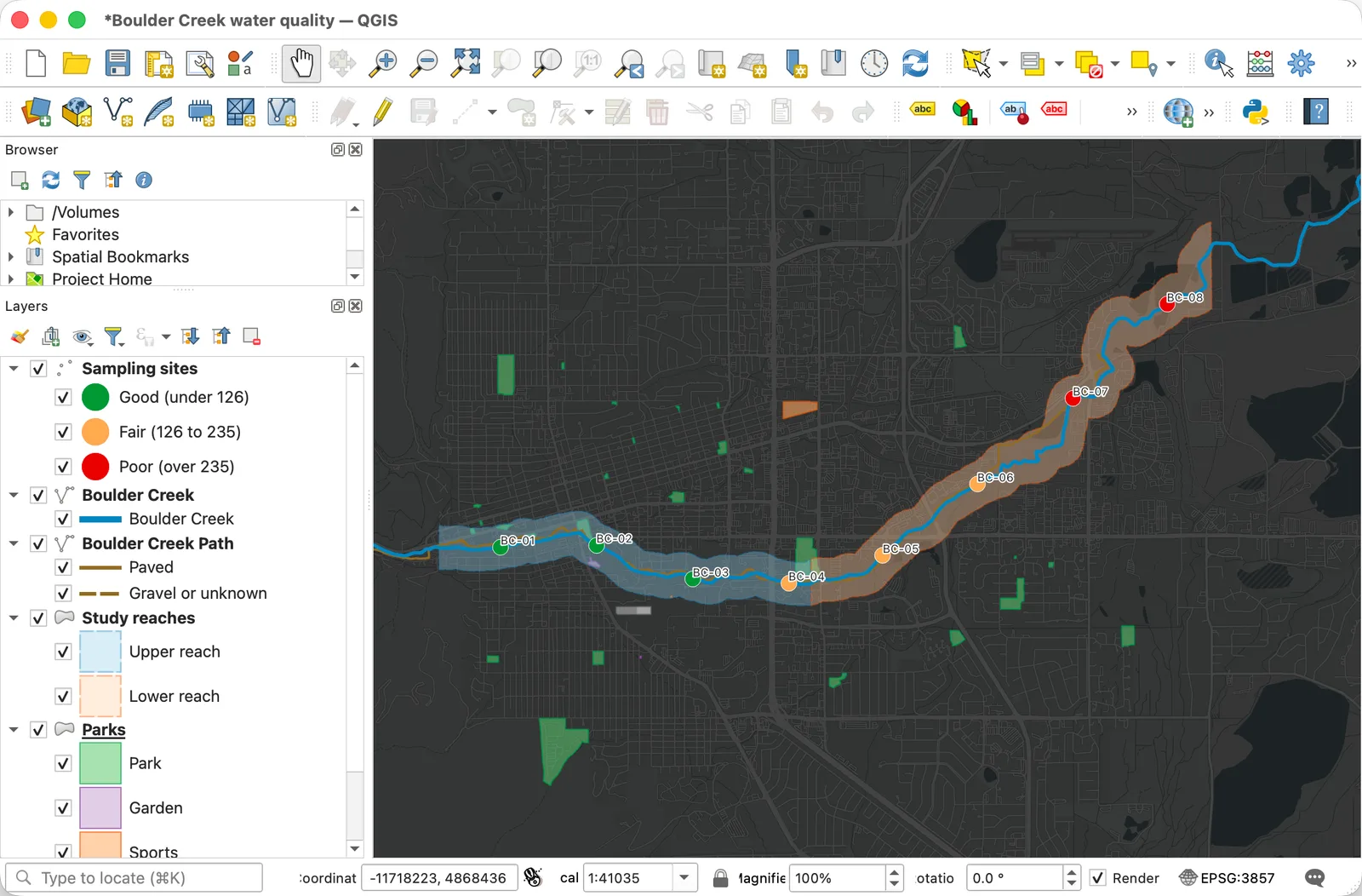
From QGIS to a link in four steps
One dialog, two tabs, and your map opens in your browser.
- 1
Open qgis2squidmaps
In your project, choose Web ▸ qgis2squidmaps ▸ Create squidmaps map.
- 2
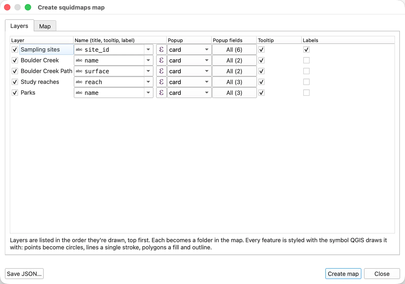
Pick your layers
Visible vector layers start checked. For each, choose what names its features, which fields its popups list, and whether it has tooltips and labels.
- 3
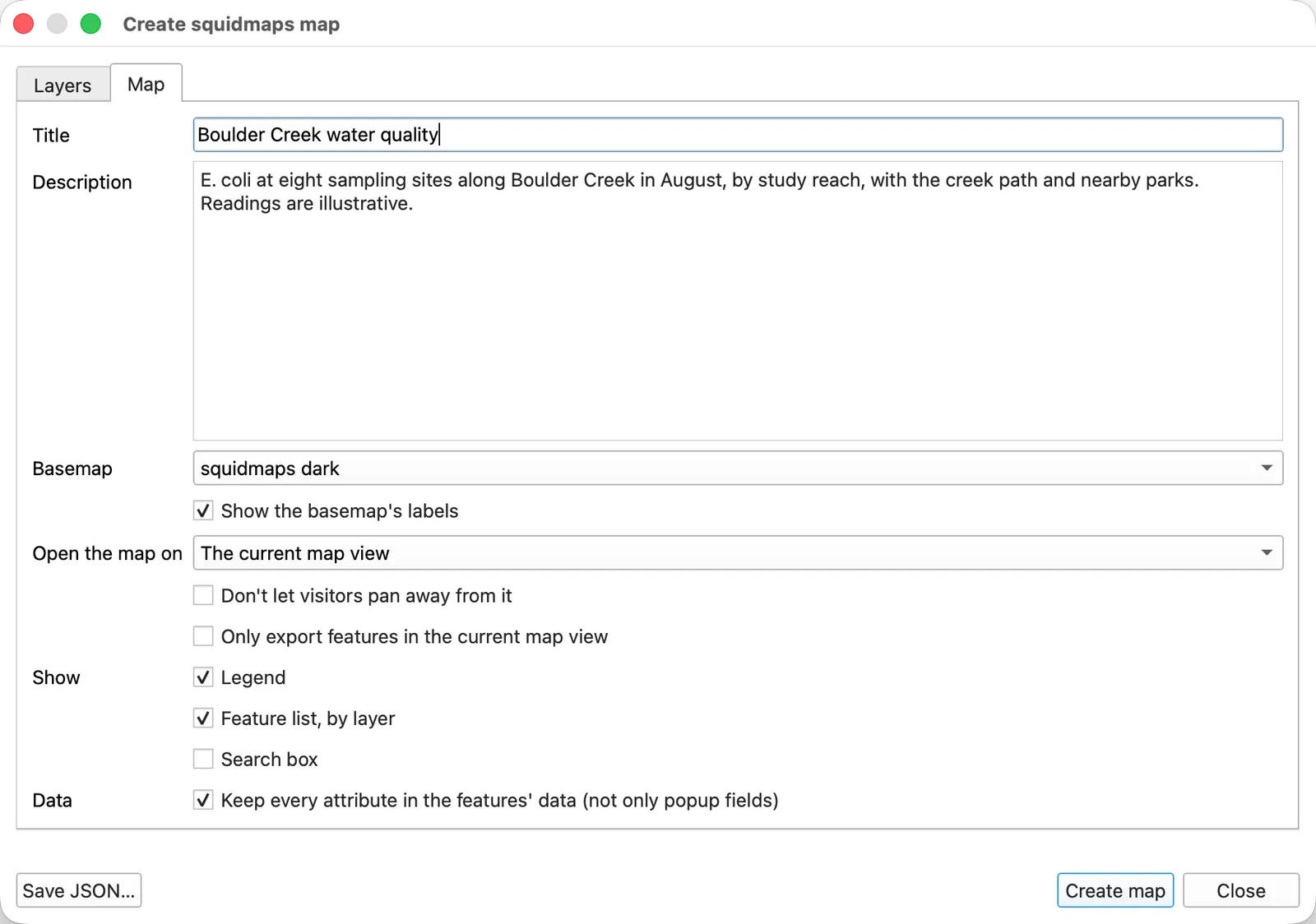
Set up the map
Its title and description (from the project's metadata), its basemap, where it opens, and whether it has a legend, a feature list and search.
- 4
Create the map
Choose Create map, and it opens in your browser with a link to share. Add it to your squidmaps account to keep it and edit it there.
The link lasts an hour after the map's last change. Changed your project? Update map replaces the map at the same link, for a day. Rather keep a file? Save JSON… writes the map as a squidmaps map document, which you can import later.
Try the map it made
The project above, published from squidmaps. Click a sampling site for its readings, or turn layers off in the panel.
Install it
From QGIS's own plugin manager, for QGIS 3.22 or later, including QGIS 4.
- 1
Open the plugin manager
In QGIS, choose Plugins ▸ Manage and Install Plugins.
- 2
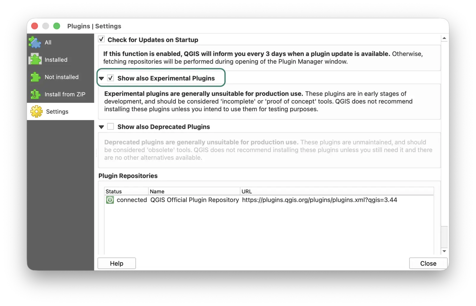
Turn on experimental plugins
qgis2squidmaps is marked experimental for now, so QGIS hides it until you ask to see those. In the plugin manager's Settings, check Show also Experimental Plugins.
- 3
Install qgis2squidmaps
Search for qgis2squidmaps, select it, and choose Install Plugin. It's in the Web menu once it's installed.
Or download it from its page on plugins.qgis.org and install the ZIP with Plugins ▸ Manage and Install Plugins ▸ Install from ZIP.
What comes across from QGIS
The plugin doesn't translate renderers: it asks QGIS how it draws each feature, and copies that.
- Every renderer: single symbol, categorized, graduated and rule-based, with rule scale ranges and data-defined colors, sizes and widths.
- Fill and stroke colors, widths, dashes and opacity, as each feature is drawn in QGIS.
- Layers, in their order, as folders that visitors can turn on and off, and as rows in the map's legend.
- The fields you choose, as each feature's popup, formatted as the attribute form shows them.
- Labels on points, in the layer's label color and size.
- The project's title and description, and the map canvas's extent.
- An XYZ tile layer from the project, as the basemap, if you choose it.
Not yet
- Raster layers, other than an XYZ tile layer as the basemap.
- Marker shapes and SVG icons: points become circles, in their colors and sizes.
- Labels on lines and polygons.
- Heatmaps, clustering, 2.5D, and showing layers only at some zooms.
- Images in features.
How big a map can be
- A map can be up to 5 MB when the plugin sends it. It checks before sending.
- To add it to your account, a map can have up to 1,000 features and 5 MB of them. The plugin warns you before it's over.
- Over a limit? Export fewer layers, only the features in view, or simplify geometries first.
Questions
How is it different from qgis2web?
qgis2web writes a Leaflet or OpenLayers website for you to host. qgis2squidmaps makes a squidmaps map instead: there's nothing to host and no HTML to keep, just a link. You can keep editing the map in squidmaps, publish it, embed it in your site, and download a picture of it.
Is it free?
Yes. The plugin is free and open source (GPL-3.0), and making, publishing and sharing squidmaps maps is free.
Where does my data go?
The layers you check are sent to squidmaps, as the features of a new map. Until you add the map to your squidmaps account, anyone with its link can open it, and it's deleted an hour after its last change. Leave out anything you wouldn't want seen.
How do I change the map after I've made it?
Change your project and choose Update map: the map at the same link is replaced, for 24 hours after it was made. Once it's in your squidmaps account, edit it there, or make a new one from QGIS.
Do I need a squidmaps account?
Not to make a map: you get a link straight away. To keep it longer than an hour, publish it, or edit it in squidmaps, add it to an account. Signing up is free.
Can I save the map without sending it?
Yes. Save JSON… writes the map as a squidmaps map document. Import it into squidmaps later, or use it with the map spec's tools.
Which versions of QGIS does it work with?
QGIS 3.22 or later, including QGIS 4, on Windows, macOS and Linux.
Something didn't come out right. Where do I say?
Open an issue on the plugin's GitHub, with the QGIS version and, if you can, the layer's style. Or email [email protected].
More about the plugin
- Its page in the QGIS plugin directory — versions and release notes
- The README — every option, and how each QGIS style maps onto squidmaps
- Report a bug or ask for something — on GitHub
- More integrations — AI assistants, the API, embedding and more
qgis2squidmaps is made by squidmaps and licensed under the GPL-3.0. QGIS is a trademark of its owner. squidmaps isn't affiliated with or endorsed by the QGIS project.